

Share This:

Manaslu Circuit Trek – The Complete Expert Guide (2026 Edition)
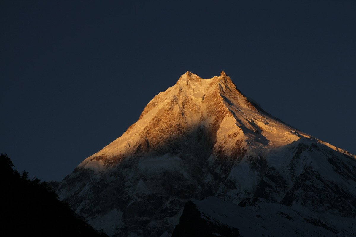
The manaslu circuit trek is one of Nepal’s most rewarding high-altitude trekking routes, encircling Mount Manaslu (8,163 m), the eighth-highest mountain on Earth. Unlike heavily commercialized trekking corridors, the Manaslu region remains geographically raw, culturally preserved, and administratively regulated under restricted area policies.
This comprehensive guide by Mountain Treks Nepal provides a medically informed, logistics-based, culturally grounded overview of the manaslu circuit trek, including detailed itinerary, altitude science, permit structure, cost breakdown, preparation strategy, safety systems, sustainability framework, and expert recommendations.
Quick Overview of the Manaslu Circuit Trek

-
Duration: 14 Days (standard itinerary)
-
Maximum Elevation: 5,106 m (Larkya La Pass)
-
Total Distance: Approximately 177 kilometers
-
Difficulty Level: Moderate to Challenging
-
Accommodation Type: Teahouse-based
-
Permit Status: Restricted Region (Special Permit Required)
-
Guide Requirement: Mandatory by law
Duration – 14 Days
The 14-day itinerary includes arrival, overland transfer to the trailhead, structured ascent, acclimatization, pass crossing, descent, and return to Kathmandu. This duration balances physical demand with proper altitude adaptation. Shorter itineraries compromise acclimatization safety, while extended routes often include Tsum Valley or Manaslu Base Camp extensions.
Maximum Elevation – 5,106 m
Larkya La Pass stands at 5,106 meters. At this altitude, atmospheric oxygen pressure drops to approximately 50% of sea-level availability. This physiological reduction requires structured ascent planning and acclimatization rest days.
Distance – 177 km
The total walking distance varies slightly depending on route variations but averages 170–180 km. Daily trekking distances range from 12 to 22 km depending on terrain and elevation gain.
Difficulty – Moderate to Challenging
Difficulty classification accounts for:
-
Sustained elevation gain
-
Long trekking hours (6–8 hours daily)
-
High pass crossing
-
Remote terrain with limited medical facilities
The manaslu circuit trek is not technically difficult but demands endurance and altitude resilience.
Why the Manaslu Circuit Trek Stands Out?

1. Restricted Access Preserves Authenticity
The manaslu circuit trek operates under Nepal’s official restricted area regulations. The Government of Nepal classifies the upper Manaslu region as a controlled trekking zone due to its proximity to the Tibetan border and its cultural sensitivity. As a result, trekkers must obtain a Manaslu Restricted Area Permit (RAP) and travel with a licensed guide through a registered trekking agency such as Mountain Treks Nepal.
This regulatory framework creates several measurable benefits:
Reduced Environmental Strain
Unlike open-access trekking regions that may host hundreds of trekkers per day during peak season, the Manaslu corridor maintains significantly lower traffic volume. Fewer trekkers result in:
-
Lower waste accumulation
-
Reduced pressure on local water systems
-
Minimal trail erosion
-
Better forest preservation
-
Controlled campsite density
The Manaslu Conservation Area spans over 1,600 square kilometers and includes fragile alpine ecosystems. Limiting foot traffic directly contributes to biodiversity protection and long-term sustainability.
Controlled Cultural Exposure
Upper Manaslu villages such as Sama Gaun and Samdo preserve centuries-old Tibetan Buddhist traditions. Restricted access prevents rapid commercialization and cultural dilution.
In many open trekking regions, tourism expansion often results in:
-
Replacement of traditional architecture with concrete structures
-
Cultural commodification
-
Loss of language preservation
-
Rapid modernization of ritual practices
The restricted permit model allows gradual, community-led tourism development rather than uncontrolled expansion.
Less Crowd Density
Crowding impacts both experience quality and safety. Popular trekking routes in Nepal often face:
-
Congested teahouses
-
Competition for accommodation
-
Trail bottlenecks
-
Overcrowded viewpoints
On the manaslu circuit trek, daily trekking density remains moderate even during peak season. This enhances:
-
Wilderness immersion
-
Acoustic quietness
-
Photography opportunities
-
Safer pace management on narrow trails
Higher Safety Compliance
Restricted region regulations require:
-
Licensed guide accompaniment
-
Registered trekking agency oversight
-
Permit documentation tracking
-
Defined entry and exit checkpoints
These mechanisms create accountability and reduce incidents of lost trekkers, unregistered trekking, and unmanaged emergencies.
The result is a trekking experience that retains raw Himalayan character while maintaining structured safety oversight.
This regulatory structure significantly enhances the wilderness integrity of the manaslu circuit trek.
2. Strong Tibetan Buddhist Cultural Influence
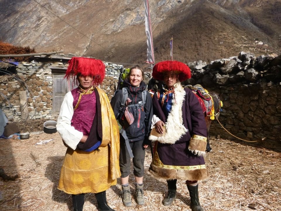
The upper Manaslu Valley reflects strong Tibetan cultural heritage, shaped by centuries of migration across the Himalayan frontier. Communities in Lho, Sama Gaun, and Samdo trace ancestry to Tibetan settlers who crossed high mountain passes generations ago.
Mani Stone Walls
Mani walls are long stone structures engraved with Buddhist mantras, most commonly “Om Mani Padme Hum.” These sacred carvings serve as spiritual offerings and protective blessings for villages.
Trekking etiquette requires passing mani walls on the left side (clockwise direction), reflecting Buddhist ritual practice.
Chortens and Prayer Wheels
Chortens (stupas) symbolize Buddhist cosmology and act as devotional monuments. Prayer wheels positioned near monasteries and village entrances contain inscribed scriptures. Rotating them clockwise symbolizes the release of blessings into the world.
These ritual structures are not decorative elements but living religious expressions integrated into daily life.
Ribung Gompa (Lho Village)
Ribung Gompa is one of the region’s most prominent monasteries. Perched above Lho village, it offers panoramic views of Mount Manaslu and serves as a center for spiritual education.
Monastic communities in the region continue:
-
Meditation practices
-
Scriptural study
-
Ritual ceremonies
-
Tibetan medicinal traditions
Yak Herding Traditions
Above 3,500 meters, yak husbandry becomes central to economic life. Yaks provide:
-
Dairy (butter, cheese)
-
Transport
-
Wool
-
Fuel (dried dung)
Seasonal migration patterns align with pasture availability, maintaining a high-altitude pastoral system largely unchanged for generations.
Cross-Border Trade Heritage
Samdo historically functioned as a trade hub between Nepal and Tibet. Salt, wool, and grain were exchanged through high mountain passes before formal border controls were implemented.
Remnants of this trading heritage remain embedded in village architecture and oral history.
Cultural immersion along the manaslu circuit trek is not staged for tourism; it represents authentic, functioning Himalayan society.
3. Diverse Ecological Zones
One of the most scientifically remarkable aspects of the manaslu circuit trek is its vertical ecological diversity.
Within approximately 170 kilometers, the route ascends from subtropical river valleys to high alpine glaciated terrain.
a. Subtropical River Valley Forests (700–1,500 m)
Lower sections near Soti Khola and Machha Khola feature:
-
Sal forests
-
Bamboo groves
-
Waterfalls
-
Agricultural terraces
Temperatures remain relatively warm compared to upper elevations.
b. Temperate Pine and Rhododendron Forests (1,500–3,000 m)
As elevation increases, vegetation shifts to:
-
Blue pine forests
-
Fir trees
-
Rhododendron forests (blooming in spring)
-
Moss-covered stone paths
This zone supports diverse birdlife and moderate wildlife populations.
c. Subalpine Yak Pastures (3,000–4,000 m)
Vegetation thins. Alpine shrubs replace tall trees. Grazing areas support yak herding communities.
Oxygen concentration decreases significantly in this elevation band, influencing trekking pace.
d. Alpine Glacial Terrain (4,000–5,000 m)
Near Dharamsala and Larkya La:
-
Sparse vegetation
-
Rocky moraine landscapes
-
Glacial streams
-
Permafrost sections
Temperatures fluctuate dramatically between day and night.
e. High Mountain Pass Environment (Above 5,000 m)
Larkya La represents a high alpine wind-exposed zone with:
-
Snow accumulation in shoulder seasons
-
Reduced oxygen availability (~50% of sea level)
-
High UV radiation exposure
This rapid vertical biodiversity transition within a single trekking corridor is rare globally and enhances the scientific and experiential value of the manaslu circuit trek.
4. High Mountain Pass Experience – Larkya La (5,106 m)
Larkya La Pass is the physical and symbolic climax of the manaslu circuit trek.
Elevation and Physiological Impact
At 5,106 meters:
-
Oxygen pressure drops significantly
-
Heart rate increases
-
Breathing rate accelerates
-
Energy expenditure rises
Early departure (typically 3–4 AM) reduces avalanche and weather risk while taking advantage of stable morning conditions.
Panoramic Mountain Views
The summit offers expansive Himalayan vistas including:
-
Himlung Himal
-
Cheo Himal
-
Kang Guru
-
Annapurna II
The wide glacial basin below the pass creates dramatic visual depth rarely matched on other Nepal treks.
Technical Difficulty Assessment
The pass is:
-
Non-technical (no rope climbing required)
-
Demanding due to duration and altitude
-
Weather-dependent
-
Snow-covered during shoulder seasons
Proper acclimatization and pacing determine safe crossing success.
Risk Management Strategy
Professional guides from Mountain Treks Nepal implement:
-
Weather monitoring
-
Early departure timing
-
Group pacing strategy
-
Oxygen saturation checks (when required)
-
Descent prioritization after summit
The pass crossing is physically demanding but achievable for well-conditioned trekkers following acclimatization protocol.
Final Expert Insight
These four elements restricted access, cultural preservation, ecological diversity, and high mountain pass experience collectively position the manaslu circuit trek as one of Nepal’s most balanced and immersive long-distance Himalayan routes.
Its strength lies not only in scenery but in regulatory structure, ecological transition, and cultural authenticity maintained through controlled tourism.
Detailed 14-Day Manaslu Circuit Trek Itinerary
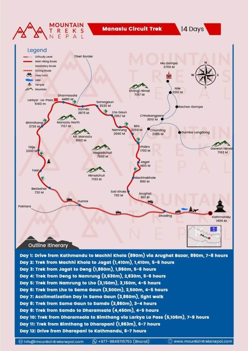
Day 1 – Arrival in Kathmandu (1,350 m)
Arrival at Tribhuvan International Airport. Transfer to hotel. Evening briefing includes:
-
Permit verification
-
Altitude education
-
Gear inspection
-
Insurance confirmation
Mountain Treks Nepal provides structured pre-departure orientation.
Day 2 – Drive to Machha Khola (890 m)
7–8 hour drive through:
-
Trishuli River corridor
-
Arughat town
-
Budhi Gandaki valley
Road conditions vary from paved to rugged mountain tracks.
Day 3 – Machha Khola to Jagat (1,410 m)
6–7 hours trekking. Trail includes:
-
Suspension bridges
-
River gorge walking
-
Terraced agriculture fields
Jagat marks official restricted region entry checkpoint.
Day 4 – Jagat to Deng (1,860 m)
Gradual elevation gain through forest sections. Cultural transition begins. Increased presence of prayer flags and Buddhist iconography.
Day 5 – Deng to Namrung (2,630 m)
Significant altitude gain. Permit checkpoint inspection. First major mountain views emerge.
Day 6 – Namrung to Lho (3,150 m)
Alpine scenery begins. First unobstructed views of Mount Manaslu north face.
Day 7 – Lho to Sama Gaun (3,500 m)
Wide glacial valley opens. Sama Gaun functions as acclimatization hub.
Day 8 – Acclimatization Day (3,500 m)
Structured rest day supports physiological adaptation. Optional elevation hikes:
-
Manaslu Base Camp (~4,800 m)
-
Birendra Lake
-
Pungyen Gompa
Return to Sama Gaun for overnight sleep at lower elevation.
Day 9 – Sama Gaun to Samdo (3,860 m)
Short walking day enhances acclimatization stability.
Day 10 – Samdo to Dharamsala (4,450 m)
Higher alpine terrain. Preparation for pass crossing.
Day 11 – Larkya La Pass (5,106 m) to Bimthang (3,855 m)
Longest and most demanding day (8–9 hours). Early morning departure required.
Day 12 – Bimthang to Dharapani (1,963 m)
Descent through rhododendron forests. Trail merges with Annapurna region.
Day 13 – Drive to Kathmandu
Return via Besisahar. Hotel transfer.
Day 14 – Departure
Airport transfer and international departure.
Altitude Sickness – Evidence-Based Guidance
Acute Mountain Sickness (AMS) risk increases above 3,000 meters.
Symptoms:
-
Headache
-
Nausea
-
Fatigue
-
Dizziness
-
Shortness of breath at rest
Prevention Protocol:
-
Gradual ascent
-
Rest day at Sama Gaun
-
3–4 liters hydration daily
-
No alcohol at altitude
-
Immediate descent if symptoms escalate
Medical Review Note
This altitude section follows wilderness medicine guidelines recognized by high-altitude medical associations. Individuals with cardiac or pulmonary conditions must obtain physician clearance. Helicopter evacuation insurance is mandatory.
Mountain Treks Nepal guides carry:
-
Pulse oximeter
-
Supplemental oxygen
-
High-altitude first aid kit
Cost Breakdown (2026)
Average group cost: USD 985–1275
Included:
-
All permits
-
Licensed guide
-
Porter support
-
Teahouse accommodation
-
All meals during trek
-
Ground transport
Excluded:
-
International airfare
-
Nepal visa
-
Travel insurance
-
Personal expenses
-
Tipping
Transparent pricing reflects regulated trekking standards.
Food and Accommodation – Detailed Overview

Teahouses provide:
-
Twin-sharing rooms
-
Shared bathroom facilities
-
Dining hall heating
-
Simple wooden beds
Meals emphasize caloric density for altitude demands:
-
Dal Bhat (unlimited refills)
-
Garlic soup
-
Tibetan bread
-
Noodles and pasta
-
Pancakes and porridge
Water purification recommended to reduce plastic waste.
Electricity, Internet & Communication
-
Solar-powered charging
-
Fee-based device charging
-
Nepal Telecom signal in lower villages
-
Limited coverage above Samdo
Power bank strongly recommended.
Physical Preparation Strategy
8–12 week training plan:
-
Cardiovascular conditioning
-
Weighted stair climbs
-
Long-duration hikes
-
Core strengthening
-
Flexibility training
Daily trekking hours: 6–8.
Sustainability & Responsible Trekking
Manaslu Conservation Area requires:
-
Leave No Trace compliance
-
Waste minimization
-
Cultural respect
-
Ethical porter treatment
Mountain Treks Nepal adheres to regulated tourism guidelines and community engagement practices.
Frequently Asked Questions
What is the highest point of the manaslu circuit trek?
Larkya La Pass at 5,106 meters.
Is the trek physically demanding?
Yes. Moderate to challenging due to altitude and sustained walking.
Are permits mandatory?
Yes. RAP, MCAP, and ACAP required.
Is a guide required?
Yes. Restricted region regulations require licensed guide.
What is the total distance?
Approximately 177 kilometers.
What is the best season?
Spring and Autumn.
Final Conclusion
The manaslu circuit trek represents a complete Himalayan experience high-altitude challenge, preserved culture, biodiversity diversity, and glacial landscapes within a regulated trekking system.
With professional logistics, medically informed altitude planning, and structured acclimatization, the manaslu circuit trek remains one of Nepal’s most balanced long-distance expeditions.
Mountain Treks Nepal delivers licensed guiding services, structured safety systems, permit coordination, and high-altitude expertise to ensure responsible trekking operations in the Manaslu region.