

Share This:
Manaslu Circuit Trek Map
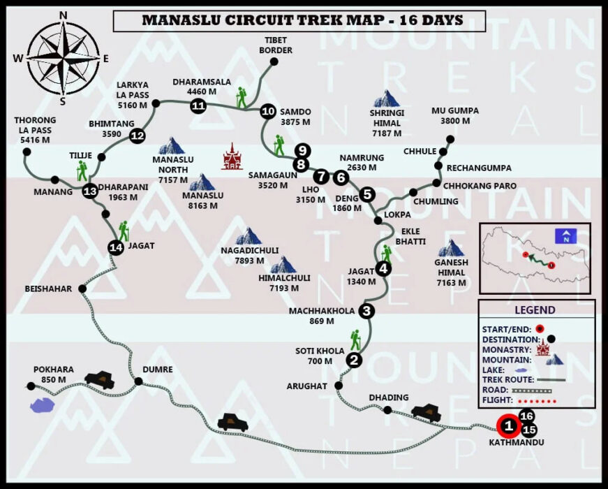
A trekking map is essential for any trek in remote areas of Nepal. This Manaslu Circuit Trek map is an easy-to read document that gives you detailed information about the trek. These maps also indicate the trekking route for this trip in great detail.
The new Manaslu trekking map includes side trips that may be possible during the journey. Manaslu Trek map gives you all the information about trekking routes and motor roads. This map will give you an idea of how far it takes to reach your destination.
Round Manaslu Map also allows you to plan your logistics and avoid unnecessary hassles. This map allows travelers to maintain a steady pace while addressing fatigue-related issues. You can also establish acclimatization stations or take shortcuts, if needed. These maps are ideal for reference because the mountainous region is not connected to the internet.
This map should be carried by trekkers throughout the trek. Continue reading to learn more about the Manaslu Tsum Valley trek map and related information.
About the Route
The Kathmandu-Soti Khola scenic route starts our journey. We pass through Dhading, Arkhet bazaar and continue on to Soti Khola. You will also start your trek to Machha Khola from Soti Khola. From Machha Khola, the trail leads to Jagat.
There are many Gurung villages that offer breathtaking views of the snow-capped mountains. After passing through Chumling and Philim, we will arrive at Chhokang Paro with Tibetan Buddhistmonasteries such as Rainjam, Tanju, and Gho. Along the trail, the beautiful Ganesh Himal range as well as the Tibetan Himalayan range are breathtaking.
You will then follow the trail to the Nile via Milarepa Cave, a sacred meditation site used by Yogi Milarepa. The trail will take you from the Nile to Bajyo and pass through Tibetan settlements close by the border. As you travel through the Dhephu Doma Nunnery Gompa, you will find many cultural insights on the Mu Gompa Trail.
The trail then crosses Yangdol Khola and arrives at Rachen Gompa. It passes by a beautiful waterfall. Rachen Gompa takes you back to Chhokangparo via Domje. The Ganesh Himal range is one of the beautiful, snow-capped mountains found in this region.
Domje to Bihi crosses Rachen and descends to Lokpa.
You will then pass through Nyak Rana, Deng and other suspension bridges. The trek will take travelers to Namrung via a flat terrain, before moving uphill through alpine forests. The Namrung to Sama Gaon Trail passes through Birendra Tal’s frozen lake.
The trail will take you to Samdo village. From there, you’ll trek to Dharamsala/Larkya Phedi via a steep trail. The Dharamsala-Bimthang trail runs through the lateral moraine at Larkya Glacier (5160m), the frozen pass of Larkya La (5160m). You will then trek to Samdo village, from where you’ll find Dharamsala/Larkya Phedi on a steep trail. The Manaslu massifs and various glaciers are breathtaking while traveling to Bimthang.
Bimthang to Dharapani, through alpine forests, will take you to Gho. The beautiful Dudh Khola will be passed by travelers. Besisahar, a four-hour off-road jeep ride from Dharapani, is also available. You will then drive back to Kathmandu. During your journey to Besisahar, you will be able to enjoy stunning landscapes with lush hills. The scenic highway route takes approximately 5-6 hours to reach the capital.
Manaslu Circuit Trek Map Description
Kathmandu – Soti Khola
Drive duration: 7-8 hours
Maximum elevation: 700m
The Manaslu Circuit Trek’s starting point is Kathmandu to Soti Khola. The trip takes you through beautiful and varied landscapes in the hilly region. The area is home to many rice fields, terrace-farmed hills, as well as serene waterfalls.
Arkhet bazaar marks the beginning of the journey. The beautiful Arkhet Khola can also be viewed, along with numerous lodges that are scattered along the trail. You can reach this destination by jeeps or local buses using a variety of transport options. Soti Khola, a lovely settlement, is full of greenery. It is also the beginning point for the Manaslu Circuit Tsum Valley Trek.
Sotikhola – Machha Khola
Trek duration: 6-7 Hours
Maximum elevation: 863m
The Soti Khola-to Macha Khola trail begins in the Budhi Gandaki Basin. It is a bumpy ride. Before reaching Liding, you will find tranquil waterfalls and other natural wonders. It’s a charming village, with a camping area and Lapubesi villages near a green hills.
You will have an unforgettable adventure in this peaceful, scenic town. You will then travel through slippery trails and exciting suspension bridges to reach Machha Khola. The village is located on a hilly slope and offers a variety of accommodation options as well as medical clinics.
Machha Khola – Jagat
Trek duration: 7-8 Hours
Maximum elevation: 1350m
This section of the trek takes you through narrow paths that run between a cliffe and the Budhi Gandaki River. After some trekking, you will reach Yaru.
You will be captivated by the stunning views of Budhi Gandaki and can also see beautiful cascades. After walking for several hours through these incredible landscapes, you will reach Jagat with its stone-paved streets. You will find basic accommodation and a campsite.
Jagat – Film
Trek duration: 3-4 Hours
Maximum elevation: 1570m
The path from Jagat to Philim winds through rugged terrain along with the Budhi Gandaki River. While en route to Philim, you will see many scenic landscapes. You will be captivated by the stunning views of snowcapped mountains along the trail, including Shringi Himal (7161m),. After a short trek, you’ll arrive at Philim. This Gurung village is home to many millet and corn fields.
Philim – Chumling
Trek duration: 6-7 Hours
Maximum elevation: 2386m
The Philim to Chumling Trail begins with a steep ascent to Budhi Gandaki River. The trail then crosses the serene Lokpa waterfall. The journey will take you through Siyar Khola and small streams, where you can admire majestic views of the snow-capped mountains like Ganesh Himal (7164m) and Shringi Himal (71161m).
Chumling – Chhokang Paro
Trek duration: 5-6 Hours
Maximum elevation: 3031m
The trail that connects Chumling and Chokkhang Paro passes through Siyar Khola. Chokkhang Paro (Tibetan-Buddhist Settlement) is home to numerous monasteries such as Rainjam, Gho and Tanju. A Dzong is also located in Chhokang Paro. From the village viewpoint, you can see the Ganesh Himal range as well as Tibetan Himalayan range.
Chumling – Gumba Lungdang
Trek duration: 6-7 Hours
Maximum elevation: 3200m
From Chulming to Gumba Lundang, the trail follows steep paths through the Himalayan foothills. Trekkers will find incredible scenery in this region, which offers them an unforgettable adventure. Many routes can be taken by trekkers to reach Ganesh Himal. This route is used by many mountaineers to reach their base camp.
Chhokang Paro – Mu Gompa
Trek duration: 5-6 Hours
Maximum elevation: 3031m
Choking Paro, a village settlement, passes through the Milarepa Cave, a sacred meditation cave dedicated Yogi Milarepa. The beautiful Chi Phu Gompa can be visited before you reach Siyar Khola, where you will find the Nile. Crossing the river is possible and you can also visit Gongye Gompa. You can extend your reach to Mu Gompa near the Tibetan border, once you have reached the Nile.
Rachen Gompa – Domje
Trek duration: 5-6 Hours
Maximum elevation: 2460m
From Rachento Domje, the trail begins with a crossing over a bridge that leads towards Choking Paro. We will reach Gompa In Gho after we descend to Siyar Khola. We will then continue along the river until we reach Domje. You will find many viewpoints along this trail, which offer incredible views of the snow-capped mountains, including Ganesh Himal.
Domje – Bihi
Trek duration: 5-6 Hours
Maximum elevation: 2130m
As we continue our trek, Domje to Bihi will be the next section. We descend towards the lower Tsum valley. After passing through several settlements of Rachen, you will arrive at Lokpa. To enter the Manaslu Circuit Trail, you will need to cross a suspension bridge over the Budhi Gandaki river. You will pass through Nyak, Deng and Rana before arriving at Bihi.
Bihi – Namrung
Trek duration: 6-7 Hours
Maximum elevation: 2630m
You will pass through several settlements on the plain terrain as you travel from Bihi, Namrung. Next, the trail climbs uphill through a lush alpine forest. Before you reach Namrung, you will be enchanted by a serene waterfall and Buddhist monasteries. Nam Gumba is a stunning attraction along a trail in Namrung. You can see Ngadi Chuli (7871m), Boudha Himal (66672m), Himal Chouli (7893m),, and other sights from this point.
Namrung – Sama Gaon
Trek duration: 7-8 Hours
Maximum elevation: 3520m
The Namrung-Sama Gaon Trail follows a path that winds along the Budhi Gandaki River, above a ridge. You will be able to see the snow-capped mountains from the Lama or Sho settlements on the route. You can visit Ribung Gompa after you arrive at Lho. We will continue on a gentle and easy trail to Shyala, but it is a steep climb. We will reach Sama Gaon, where we’ll explore the area, including the sacred Pema Choling Lhakhang.
Sama Gaon – Samdo
Trek duration: 4-5 Hours
Maximum elevation: 3875m
From Sama Gaon, the trail to Samdo offers breathtaking views of snowcapped mountains including Manaslu (8126m). As you climb gently towards Samdo on a quiet trail, we will see more of these beautiful mountain peaks. The Taka Choling Gompa is located in Samdo.
Samdo – Dharamsala/Larkya Phedi
Trek duration: 5-6 Hours
Maximum elevation: 4460m
From Samdo to Dharamsala, a beautiful trail passes through streams and reaches Larkya Bazaar. After passing through Mani walls, the steep trail climbs up to Larkya La (5160m).
Dharamsala-Bimthang
Trek duration: 7-8 Hours
Maximum elevation: 3590m
From Dharamsala, the trail to Bimthang takes you through the Larkya Glacier. It then leads to Larkya La (5160m). These mountain passes offer stunning views of the Annapurna and Manaslu massifs. You will then descend through an icy path, which offers breathtaking views of the glacier as you reach Bimthang.
Bimthang – Dharapani
Trek duration: 7-8 Hours
Maximum elevation: 1963m
You will find beautiful settlements and alpine forest on the trail from Bimthang, Dharapani to reach the Gho. You will travel along the trail, passing through small settlements such as Tilje. From Tilje to Dharapani, it is descending. To reach this lovely settlement, you will continue to the suspension bridge above Dudh Khola.
Dharapani – Besisahar
Drive duration: 4-5 hours
Maximum elevation: 1963m
You will travel on an off-road trail from Dharapani, India to Besisahar. To reach Besisahar, you can take a jeep that takes around four hours. To reach Syange village, you will follow a downward trail. The trail continues to climb to Gharmu Phant, before eventually descending to Besisahar.
Besisahar – Kathmandu
Drive duration: 6-7 hours
Maximum elevation: 1300m
The scenic drive from Besisahar, Nepal to Kathmandu takes approximately 6-7 hours. All travelers will be captivated by the beautiful landscapes featuring lush green hills and other river banks. You can also take an alternate trip to Pokhara from Dumre.
Why is Manaslu Circuit Trek Map so Important?
The Manaslu Circuit Tsum Valley Trek Map is a great piece of information to help you navigate the remote and rugged terrains. This map gives trekkers all the information they need about elevation, time duration, and trekking distance. These are the key elements of the map:
Plan in advance
Trekkers will find the Manaslu trekking map useful in planning their adventures. The maximum elevation, duration, trek distance and other details will be provided to travelers. The map provides additional information such as the destination and arrival points, which can be very helpful in planning the trek.
Great for side trips
Information about side trips is also provided on the Manaslu Circuit Tsum Valley trek map. These maps provide information about the various acclimatization points you can choose from to avoid altitude sickness in high elevation regions. The map also shows the lesser-known routes within the Tsum Valley Manaslu area.
Ideal for remote treks
Manaslu’s trek map is perfect for remote terrains and areas with poor connectivity. This map can be used by trekkers without a reliable internet connection to help them navigate the trail. You can also find out about restricted areas and no entry zones to ensure you are safe. Maps are useful for preventing trekkers from becoming lost along the trail and keeping them safe.
The Final Word
Manaslu Tsum Valley Trek is an adventure in stunning Himalayan landscapes. This trek also passes through the Himalayan foothills. The Manaslu Circuit Tsum valley trekking map is an essential resource during your trekking adventure.
This map can be used by trekkers to navigate the various landscapes in the region. This map also shows important factors such as maximum altitude, time duration, and trekking distance. The Manaslu Circuit Tsum Valley Trek Map is great for anyone who wants to trek this route.
Error: Contact form not found.